In this post, we learn about the Geological work of rivers concerning erosion, Transport, and Graduation this question is many times asked in the final or end-semester exams. So Try to must understand the Concept of the Geological work of the River.
Table of Contents
Q. Explain the geological work of rivers concerning erosion, Transport, and Gradation?
Fluvial geomorphology is very important in major civil engineering operations. The most prominent landforms seen on the earth’s surface are developed by fluvial action, though other processes also substantially contribute to their modification and development.
An understanding of applied fluvial geomorphology, including the quantitative study of sediment load, is essential where a dam is to be constructed across a river valley as a part of hydroelectric and irrigation projects. The study is useful in calculating the life of a reservoir. In rare cases, the river may flood, overflow their banks and an abnormal sediment load may be deposited over their flood plains.
The capacity of a river to carry sediment load and erode its channels, laterally as well as vertically, is evaluated by the amount of energy it possesses.
A river has potential energy controlled by the amount of water present (volume) and the head of the water (vertical distance above sea level). The kinetic energy (energy of movement) generated by the river is evaluated by the flow of water and its velocity i.e. discharge rate. Thus, an increase in the discharge of water and its velocity leads to an increase in river energy. Rivers may show substantial spatial as well as temporal variations.
Fluvial Classification system:
Rivers normally flow into channels cut either into bedrock or in alluvial (recent) sediments. Rivers in bedrock tend to follow a stable course while those in alluvium have a strong tendency to change their position and behaviour. Failure to understand the natural behavior of alluvial river systems can lead to damaging effects particularly if artificial changes are introduced in the system.
Bedrock channels are likely to be much more irregular than alluvial channels. Whether in alluvium or bedrock, the Thalweg, or line connecting points of maximum water depth in a generally downstream direction along the channel is rarely straight.
In humid regions, rivers are called Effluent as they receive water from groundwater too. Rivers in arid regions generally lose water to the ground in addition to losing it by evaporation and they often dry up completely without reaching the sea are called Influent streams.
The shape of the river channel segment is used to describe different terms. Some segments are straight in plan view. Sinuous channels develop in bedrock and alluvium either by rounding the corners of zigzag channels or alternately eroding and depositing sediment as pools and riffles along former straight reaches.
Fluvial Erosion:
Erosion by a river or a stream is the process of continuous removal of weathered material from in situ, • The most common process of stream erosion is mechanical abrasion or corrosion. The rate of corrosion depends on the volume of water, the gradient, and the hardness, and softness of the bedrock. The coarse disintegrated particles of hard rock are rolled and dragged along the channel floor, slowly removing away exposed rock outcrops.
Potholes are often created in the beds of fast-flowing rivers due to strong eddy motions by the swirling action of pebbles. The sheer hydraulic power exerted by rapid river flow, referred to as pot-hole drilling may also be responsible for the shattering of bedrock in the channel. The process becomes easier if joints and bedding planes are widened by localized corrosion or chemical attack.
Erosion by a river or a stream is influential in three interactions; viz vertical downcutting, lateral erosion, and headward erosion.
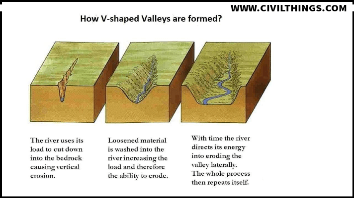
1. Vertical Downcutting:
Vertical downcutting is particular to the fast-flowing rivers that transport a large bed load. The bed load is used to abrade and pothole the channel floor, which leads to the formation of deep narrow gorges, waterfalls, and cascades.
2. Lateral Erosion:
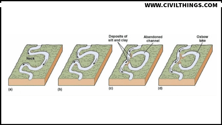
Once the temporary base level is attained, the kinetic energy of the river is used for lateral excavation causing bank erosion. However, the role played by weathering and slope transport in the process of valley widening is substantial. As a result of these interactions meanders or sinusoidal bents are developed.
3. Headward Erosion:
Headward erosion is prominent where the river profile is steep. It is associated with waterfalls where an alternate sequence of hard and soft rock is observed. Thus, on steepened valley sections, the rapidly flowing water increases the rate of erosion with the result that steepened section migrates upstream.
Fluvial transport:
The theoretical maximum load that a stream can transport is considered as its capacity; while competence is the measure of a river’s ability to transport a maximum grain size of disintegrated particles. It depends on the factors like velocity, shape, and size of particles, the temperature of the water, etc.
The weathered material (disintegrated and decomposed) is transported in three forms:
1. Bed Load:
Bed load is often a permanent load situated in the river channel. It includes the gravel and large-size fragments, transported close to the channel floor by rolling or sliding.
2. Suspension Load:
Clay, silt, and sand particles transported during moderate/high flow are called suspension loads.
3. Solution Load:
The decomposed material available in solution or colloidal mixtures is called dissolved or solution bed.
Fluvial Gradation:
The concept of stream gradation is controlled and influenced by many factors including discharge, sediment load, base level, channel width, depth, bed roughness, etc. The fluvial system is said to be graded if the stream channel system adjusts its gradient and attains an average steady state of operation for a measurable period.
The system is then said to have achieved an equilibrium state of operation. The equilibrium may be achieved in a process of a gradational step Thus, the concept of a river in the graded system may be visualized by first imagining an ungraded river that flows over a tectonic landscape, newly raised from the other normal land or the floor of the sea.
Rainfall varies over the landscape, water flows down- the slope along easy water-carrying paths. Drainage networks are eroded and valleys are broadened by wasting on slopes along the deeper channels.
FAQ
What is the geological work of rivers concerning erosion?
What is the geological work done by rivers?
What is the work of the river as an agent of gradation?
What is the geological classification of rivers?
What is river transportation in geology?
What are the five geological processes?
Why is the work of erosion and transportation of a river?
What are the stages of river geology?
What is called geological erosion?
What are the different types of geographical erosion?
What are the effects of erosion in geology?
What are the geological factors of soil erosion?
What are the 4 major geological processes?
What are the 4 geological features?
What are the 4 geological processes that occur within the Earth explain?
How many types of river erosion are there?
What are the erosional features of a river?

Hi! I’m Sandip, a civil engineer who loves sharing about Civil Engineering & new ideas and tips. My blog helps you learn about engineering in a fun and easy way!